

How to get to the new Pinehurst light rail station in north Seattle
The light rail is a great way to get around Seattle quickly and affordably. But before you can get where you’re going – you need to get to the nearest station.
Sound Transit’s new Pinehurst Station opens on Sept. 30 in north Seattle. To help you get there, we’ve been building more sidewalks, new protected bike lanes, fresh Neighborhood Greenways, and better connections leading up to the station.
We’re always working to help you more easily connect to transit, because transit works best when people can safely and comfortably reach it.
Whether you walk, roll, bike, ride the bus, or drive – here are some tips to help you get to the new Pinehurst Station.
Jump to:
Know before you go
To start, here are a few things you need to know.
There isn’t a parking garage or lot at Pinehurst Station. Other light rail stations north and south of Pinehurst do have parking, which you can learn more about on Sound Transit’s website.
These include:
- Shoreline South/148th Station – 500 spaces
- Northgate Station – 443 spaces, plus nearby park-and-ride lots
The passenger pick-up and drop-off area is located north of the new station on 5th Ave NE (just east of I-5, and just north of NE 130th St).
Bike parking is available on-site. Pinehurst Station can fit 28 bikes in bike racks, plus another 20 in BikeLink lockers, which are available on demand.
There are two bus stops just south of the station that serve King County Metro’s new Route 77 bus.
How to pay: There are ORCA ticket machines on the north and south ends of the station, where you can buy tickets, an ORCA card, or pay cash. To use your phone, you can buy a ticket using the Transit GO ticket app or simply tap your credit or debit card on the readers.
To learn more about how to pay for transit in Seattle, watch our video on YouTube. Check out our Seattle Transit 101 playlist for more how-to guides.
Taking transit
Pinehurst Station is opening as King County Metro recently launched Route 77, a new bus route connecting you directly to the station.
Routes with stops near Pinehurst Station:
-
Route 77: A new King County Metro bus route with stops right across from the southeast corner of Pinehurst Station.
- Nearest stops: 130th St & 5th Ave NE (eastbound); Roosevelt Way Ne & 5th Ave Ne (westbound)
- Connects to: Bitter Lake, Roosevelt Station, U District Station, and Seattle Children’s Hospital
-
Route 75: A King County Metro bus route with stops about three blocks south of Pinehurst Station.
- Nearest stops: 5th Ave NE & NE 123rd St (northbound and southbound sides of 5th Ave):
- Connects to: Northgate, Lake City, Sand Point, Seattle Children’s Hospital, University District
You can plan your route with King County Metro’s Trip Planner. For travel alerts, visit King County Metro’s service advisories page.
TRAVEL TIP: In Seattle, anyone 18 or younger can ride most transit for FREE and discounted fares are available for adults who qualify. This is true for light rail, Seattle Streetcar, King County Metro and Sound Transit buses, ferries, and water taxis.
Walking, biking, rolling
We’ve been working on projects near Pinehurst Station to make it easier to get to by walking, biking, and rolling.
Here’s a look at some in the area that are complete, in construction, or coming soon, with links where you can learn more and subscribe to project updates.
Some projects include Neighborhood Greenways and Healthy Streets, which are safer, calmer streets for walking and riding bikes. They have signs and traffic markings to help you find your way, traffic calming measures like speed humps or traffic circles, and are usually connected to other nearby trails or protected bike lanes.
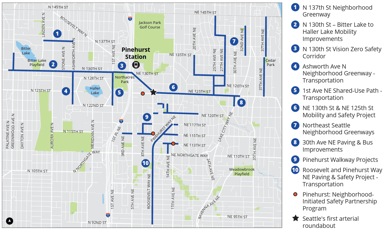
1. N 137th St Neighborhood Greenway
Status: Coming soon
Learn more and subscribe to updates: N 137th St Neighborhood Greenway
We are building a Neighborhood Greenway on N 137th St between Linden Ave N and Ashworth Ave N. It will connect to the Interurban Trail, the Ashworth Ave N Neighborhood Greenway, and more improvements on N 130th St that help people get to the Pinehurst Station and Metro Route 77.
2. N 130th St – Bitter Lake to Haller Lake Mobility Improvements
Status: Coming soon
Learn more and subscribe to updates: N 130th St – Bitter Lake to Haller Lake Mobility Improvements
Upgraded sidewalks and bus stops, new protected bike lanes, street trees, and so much more. This project on N 130th St between Palatine Ave N and I-5 will make it easier to get to Broadview Public Library, Bitter Lake Community Center, Ingraham High School, Metro Route 77 bus stops, and, of course, the new Pinehurst Station.
NEW SIDEWALKS: We’re also building new sidewalks as part of a separate project nearby. The Greenwood Ave N Sidewalk Improvements project is a bit further south, between N 112th St to N117th ST and N 134th St to N 137th St.
3. N 130th St Vision Zero Safety Corridor
Status: Complete
Learn more: N 130TH St Vision Zero Safety Corridor
Last year, in response to an analysis of crash data involving people walking and biking, we made safety upgrades on N 130th St between 1st Ave NE and Stone Ave N as part of our Vision Zero commitment to end traffic deaths and serious injuries on city streets.
This includes a street redesign that brought the number of lanes for cars down from four to three, with one lane in each direction and a center turning lane.
We also lowered the speed limit from 30 mph to 25 mph, built new protected bike lanes, and added new turning restrictions for people driving.
4. Ashworth Ave N Neighborhood Greenway
Status: Phase 1 complete, more coming soon
Learn more: Ashworth Ave N Neighborhood Greenway
New crosswalks, pedestrian lights, speed humps, and more. The Ashworth Ave N Neighborhood Greenway between N 135th St and N 120th St makes it easier to walk or bike to Haller Lake, UW Medical Center, James Baldwin Elementary, and Ingraham High School. It connects to Pinehurst Station via N 130th St and the 1st Ave Shared Use Path.
5. 1st Ave NE Shared-Use Path
Status: Coming soon
Learn more and subscribe to updates: 1st Ave NE Shared-Use Path
Running parallel to the Ashworth Ave Greenway will be a shared-use path for walking and biking on 1st Ave NE between NE 130th St and NE 120th St.
This path is part of our Safe Routes to School program and the New Sidewalks and Walkways program, which you can read more about below. It will connect James Baldwin Elementary School, Northacres Park, NE 130th St, and Pinehurst Station.
6. NE 130th St & NE 125th St Mobility and Safety Project
Status: In construction
Learn more and subscribe to updates: NE 130th St & NE 125th St Mobility and Safety Project
New bus stops, bus-only lanes, protected bike lanes, sidewalks repairs, better crossings, and more along NE 130th and 125th Streets. This project includes a street redesign that will make it safer to make left turns and reduce conflicts between people driving and people walking, biking, or rolling.
It also includes Seattle’s first major roundabout at Roosevelt Way NE & 10th Ave NE to improve traffic flow and safety. The roundabout has flashing crossing beacons and concrete curb protected bike lanes. Learn how to use the roundabout in our blog post.
7. Northeast Seattle Neighborhood Greenways
Status: Complete
Learn more: Northeast Seattle Neighborhood Greenways
We’ve already mentioned a few Neighborhood Greenways to the west of Pinehurst Station on N 137th St and Ashworth Ave N.
Northeast of the station you’ll find more greenways and Healthy Streets, which are residential streets closed to through traffic. Like greenways, Healthy Streets create a calm environment for people walking, biking and rolling, and often connect to other trails and bike lanes.
- Olympic Hills: From NE 145th St down to NE 125th St, and 20th Ave NE to 27th Ave NE. These greenways and Healthy Streets connect Olympic Hills Elementary, Lake City Library, and Pinehurst Station.
- Little Brook: Connecting Little Brook Park to the Olympic Hills greenways and Pinehurst Station.
- Cedar Park: East of Olympic Hills, also stretching from NE 145th St down to NE 125th St. Connects Cedar Park, Cedar Park Elementary, Laurel Academy Elementary.
8. 30th Ave NE Paving & Bus Improvements
Status: In construction
Learn more and subscribe to updates: 30th Ave NE Paving & Bus Improvements
Paved streets, a new sidewalk, better crossings, and more. This project supports King County Metro’s new bus Route 77 with improvements on 30th Ave NE between NE 125th St and Lake City Way NE.
9. Pinehurst Walkway Projects
Status: Coming soon
Learn more and subscribe to updates: Pinehurst Walkway Projects
Pinehurst is getting 28 blocks of new sidewalks and walkways, in areas you helped choose during last year’s neighborhood community walks, or “walkshops.” We wrote a blog post about this back in May.
These are the first sidewalks and walkways to come from our new sidewalks and walkways program and are part of a Seattle Transportation Levy-funded initiative to add 350 blocks of new sidewalks and walkways across the city throughout the life of the levy.
This is just the beginning. Thanks to your feedback, we now have an early list and interactive map of more than 200 locations across Seattle we are considering. We’re working to build as quickly as possible, with 250 blocks to be built within the next four years.
10. Roosevelt and Pinehurst Way NE Paving & Safety Project
Status: Coming soon
Learn more and subscribe to updates: Roosevelt and Pinehurst Way NE Paving & Safety Project
We’re repaving Roosevelt Way NE and Pinehurst Way NE between NE 92nd St and 15th Ave NE to extend the life of the street pavement by 10 to 20 years. We’re also building new protected bike lanes, crosswalks, fixing sidewalks, improving bus stops and more. This project is near Olympic View Elementary, Hazel Wolf K-8, and Beaver Pond Natural Area.
A more connected Seattle
Together, these projects form a connected network of sidewalks, greenways, protected bike lanes, and safer crossings that surround Pinehurst Station from every direction.
Each one supports the Seattle Transportation Plan‘s goal of providing safer routes to transit and reflects the Vision Zero commitment to eliminate serious injuries and deaths on Seattle streets.
Locally funded
Many of these projects were made possible because of voter-approved sources like the Seattle Transportation Levy and the 2020 Seattle Transit Measure (STM).
Generally, levies tend to pay for infrastructure projects, like new sidewalks and bike lanes, while STM investments expand transit services, like additional bus routes on Route 77 and 75.
Getting around Seattle: Tools and resources
There are many ways to get around Seattle. Some options include:
- First Hill Line: 1.3 miles with seven stops connecting South Lake Union to downtown Seattle.
- Buses (King County Metro)
- Ferries (Washington State Ferries)
- Metro Flex (Neighborhood specific on-demand service provided by King County Metro. Available in Seattle in Othello, Delridge / South Park, and Rainier Beach)
Not sure where to start? Try FlipYourTrip.org!
With tips organized by travel mode, how-to videos, links to resources from our transit partners, and more — FlipYourTrip.org is a one-stop hub to help you plan car-free travel in Seattle.
Stay connected
We regularly share updates, tips, and travel information across SDOT channels so you can stay informed and plan your routes with confidence.
If you like this story, you may also like:
More ways to follow along:
Web | Blog | X | X Traffic | Instagram | TikTok | Facebook | LinkedIn | YouTube | Flickr | Customer Service | Alert Seattle
Legal Disclaimer:
EIN Presswire provides this news content "as is" without warranty of any kind. We do not accept any responsibility or liability for the accuracy, content, images, videos, licenses, completeness, legality, or reliability of the information contained in this article. If you have any complaints or copyright issues related to this article, kindly contact the author above.
